Subscribe
70°

Colder Air, Snow: Timing, Updates On New Winter Storm In NJ, PA
More seasonable weather is on the way this weekend, forecasters say.
Following days of spring-like temps, colder air more suitable for January days, along with a wintry mix, is headed to New Jersey and Pennsylvania in the next two days, according to AccuWeather and the National Weather Service.
Coastal low pressure will begin to bring mainly rain to the region tonight. Total rainfall is not expected to be all... Posted by US National Weather Service Philadelphia/Mount Holly on Saturday, January 27, 2024
"A pattern change featuring a return to colder air more typical of conditions f…
Chance Of Snow For NJ, PA In Sunday Soaker: Forecasters
Temperatures are expected to surge near 60 by the end of the week, but come next, parts of New Jersey and Pennsylvania could be back in old man winter's grip, forecasters say.
According to AccuWeather, a storm on Sunday, Jan. 29 will bring rain to major cities.
For northwest New Jersey, northern Pennsylvania and parts of Central Pennsylvania, however, a mix of rain and snow — or perhaps just snow — is expected.
Thursday, Jan. 25 will be rainy and foggy with a high near 50 while Friday, Jan. 26 will be the same but slightly cooler, the NWS said. Saturday will be partly sunny with a hi…
Snow Emergencies Declared Across PA Ahead Of Storm
Officials are advising residents across southeastern and central Pennsylvania to take caution ahead of the snowstorm predicted for Friday, Jan. 19, according to National Weather Service meteorologists.
Chester, Delaware, Philadelphia, and parts of lower Bucks and Montgomery counties are under a winter storm warning as of 5 p.m. Thursday. In Adams, Berks, Cumberland, Dauphin, Lancaster, Lebanon, Lehigh, Northampton, and upper Bucks and Montgomery counties, a winter weather advisory is in place.
NWS's Mount Holly, New Jersey station says snow will begin to fall around 4 to 7 a.m. …
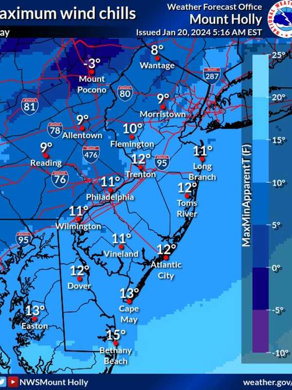
New Forecast: Increased Snowfall Totals Expected, Arctic Temps To Follow Northeast Storm
Newly-released forecast maps show parts of the region could see up to six inches of snow in the end-of-week storm.
Intermittent snow is expected to begin between 4 and 7 a.m. Friday, Jan. 19, with the heaviest amounts falling in the afternoon, the National Weather Service said.
Snow will fall at about 0.5 inches per hour and will taper by the evening, with temps in the upper 20s and low 30s, the NWS said.
SNOWFALL PREDICTIONS
The areas expected to get 4 to 6 inches are Trenton, Long Branch, Allentown, and Philadelphia. Reading, Vineland, Parsippany and Toms River are expected to get 3 to …
Here's Who Got The Most Snow In Southeastern Pennsylvania
Greater Philadelphia woke up in a winter wonderland Tuesday, Jan. 16 as a wintry system worked its way up the eastern seaboard Monday night, Jan. 15, and into the early morning hours.
Though the snowfall has mostly tapered off, winter weather advisories remain in effect as of 3 p.m. Tuesday for Berks, Bucks, Chester, Delaware, Lehigh, Montgomery, Northampton, and Philadelphia counties, said the National Weather Service.
Here's how snowfall totals stacked up across the region in the last 24 hours, according to NWS meteorologists.
Berks County had its highest snowfal…
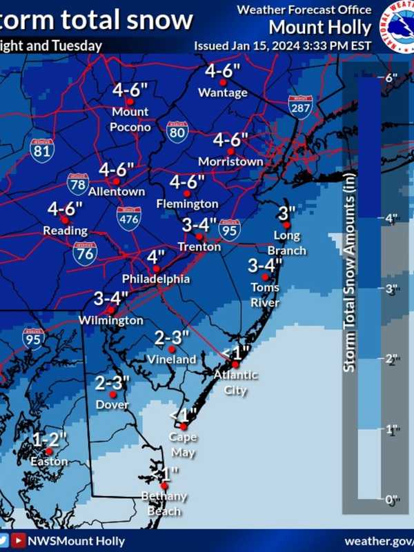
Six Inches Of Snow Could Slam Parts Of NJ, PA: Latest Forecast, Timing Updates
Newly-released forecast maps from the National Weather Service show up to six inches of snow could fall across eastern Pennsylvania and much of New Jersey.
Accumulating snowfall will begin Monday, night Jan. 15, mainly after 7 p.m., and carry into Tuesday morning, Jan. 16, impacting the morning commute as it changes over to a wintry mix, the NWS said in its latest briefing.
ALSO SEE: North Jersey School Delays For Tuesday, Jan. 16
Between 4 and 6 inches of snow was being forecast for most of North Jersey (including Morris, Sussex, pars of Bergen/Essex/Hudson, Warren, and Hunterdon Counties…
Possibility Of Snow, Ice Storm For Northeast Next Week Hinges On One Factor: AccuWeather
A winter storm could hit the Northeast next week, but it depends on one factor, forecasters say.
A dip in the jet stream.
“Should a large dip develop in the jet stream, then a major winter storm will climb the Atlantic coast from Monday night to Tuesday night,” AccuWeather Senior Meteorologist Bob Smerbeck explained.
“However, should only a shallow dip in the jet stream develop, the storm would be more likely to escape out to sea, off the southern Atlantic coast by midweek.”
Weather maps show a dusting of between one and three inches, should the snow make its way up to New Jersey, eastern…
Storm Downs Trees, Closes Roads Across Southeastern PA
Authorities advise residents to adjust their travel routes after heavy rains flooded parts of greater Philadelphia Tuesday night and into Wednesday morning, Jan. 9 and 10.
Flood and coastal flood warnings remain in effect Wednesday for Philadelphia and parts of Bucks, Chester, Delaware, Montgomery, Lehigh, and Northampton counties, according to meteorologists at the National Weather Service.
Drivers should take care to avoid flooded roadways and should never drive into pooled water, authorities note.
Here is a rolling, inexhaustive list of the most recent travel advisorie…