Cross-Country Storm Packed With Snow, Ice Takes Aim On Northeast Cross-Country Storm Packed With Snow, Ice Takes Aim On Northeast
Cross-Country Storm Packed With Snow, Ice Takes Aim On Northeast A quick-moving New Year's Eve storm system that brought some natural fireworks as 2025 arrived will be followed by strong wind gusts of up to 50 miles per hour that could lead to power outages before a winter storms makes its way to the East Coast. Temps will become more seasonable on Thursday, Jan. 2, with lingering strong winds making it feel colder. From Friday, Jan. 3 to Sunday, Jan. 12, temperatures will be between 12 and 25 degrees below the historical average.  The return of colder air will set the stage for a massive storm that will move along a 1,500-mile-long zone from the M…
Freezing Rain To Glaze Roadways With Ice: Winter Weather Advisories Issued Across NJ, PA Freezing Rain To Glaze Roadways With Ice: Winter Weather Advisories Issued Across NJ, PA
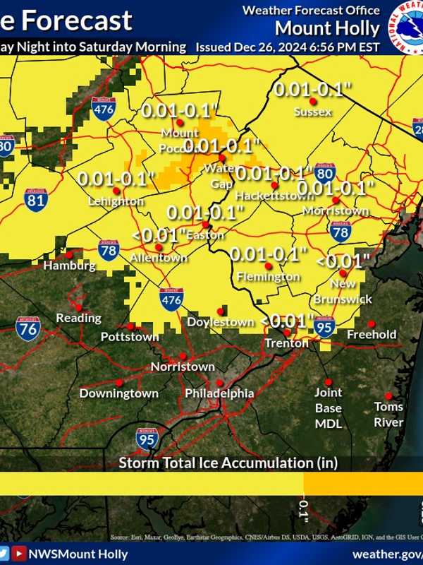
Freezing Rain To Glaze Roadways With Ice: Winter Weather Advisories Issued Across NJ, PA A Winter Weather Advisory has been issued for parts of New Jersey and Pennsylvania as freezing rain is expected to create icy road conditions Friday night, Dec. 27 into Saturday morning, Dec. 28, according to the National Weather Service (NWS). The advisory is in effect from 7 p.m. Friday to Saturday. Ice accumulations of up to one-tenth of an inch are anticipated in Sussex, Warren, and Morris counties, in NJ, and Lehigh and Northampton counties, in PA. "Very slippery sidewalks, roads, and bridges are possible," the NWS warned. Motorists are urged to slow down and exercise caution while dri…
4 Inches Of Snow Fell In Parts Of Bergen County: Here's How Much Your Town Got 4 Inches Of Snow Fell In Parts Of Bergen County: Here's How Much Your Town Got
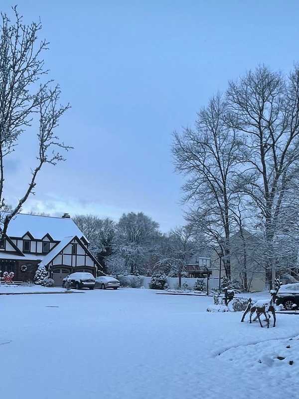
4 Inches Of Snow Fell In Parts Of Bergen County: Here's How Much Your Town Got A winter storm dropped varying amounts of snow across New Jersey overnight Friday, Dec. 20, into Saturday morning, Dec. 21.  Snowfall totals ranged from trace amounts in South Jersey to more than 5 inches in parts of North Jersey, creating slippery conditions on roadways as temperatures remained below freezing, according to data from the National Weather Service. Sussex and Morris counties recorded the highest snowfall, with Sparta Township leading at 5.5 inches and Randolph Township close behind at 5.3 inches. Meanwhile, southern counties like Atlantic and Cumberland reported only tra…
Up To 3 Inches Of Snow Expected This Weekend In Albany Area: Here's Your Forecast Up To 3 Inches Of Snow Expected This Weekend In Albany Area: Here's Your Forecast
Up To 3 Inches Of Snow Expected This Weekend In Albany Area: Here's Your Forecast A winter storm is poised to bring light to moderate snowfall to eastern New York, western Massachusetts, and parts of Connecticut from Friday morning, Dec. 20 through Saturday evening, Dec. 21, according to the National Weather Service. A Hazardous Weather Outlook has been issued for the region, warning of slippery travel conditions, particularly during the Friday evening commute. While snowfall amounts are expected to remain below advisory levels—less than 4 inches—hazardous road conditions are likely. Thursday will be partly sunny with a high near 39°F and northwest winds of 7 to 10 mph, …
1 To 3 Inches Of Snow Expected This Weekend In Parts Of NJ, PA: Here's Your Forecast 1 To 3 Inches Of Snow Expected This Weekend In Parts Of NJ, PA: Here's Your Forecast
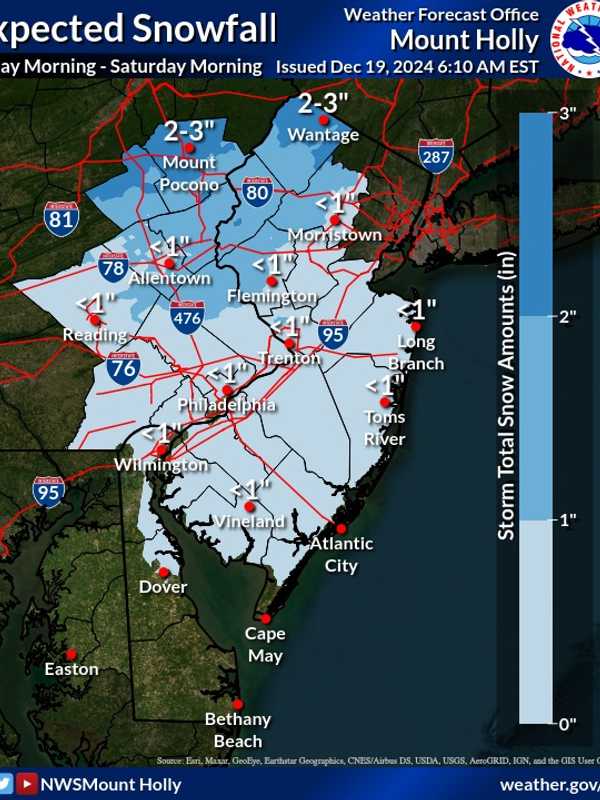
1 To 3 Inches Of Snow Expected This Weekend In Parts Of NJ, PA: Here's Your Forecast A weak winter system is expected to bring a mix of light snow and rain to parts of New Jersey and Pennsylvania beginning Friday morning, Dec. 20, and lasting into early Saturday, Dec. 21, the National Weather Service (NWS) in Mount Holly said. A weak system will move through Friday into early Saturday morning, bringing a mixed bag of wintry weather across the... Posted by US National Weather Service Philadelphia/Mount Holly on Thursday, December 19, 2024 The Poconos and northwest New Jersey are expected to see the most snow, with accumulations ranging from 1 to 3 inches. Areas north…
Snow Totals Released: Here's How Much Snow Your Town Saw This Week Snow Totals Released: Here's How Much Snow Your Town Saw This Week
Snow Totals Released: Here's How Much Snow Your Town Saw This Week The National Weather Service has released snow totals from this week's winter storm. Snowfall accumulation impacted areas across New Jersey, Pennsylvania, Connecticut, and New York, with Sussex County, NJ, and Putnam County, NY, seeing the highest totals from Sunday, Dec. 15 into Monday, Dec. 16. Below are detailed figures reported by state, county, and town, as per the National Weather Service: New Jersey Mercer County: Trenton Mercer Airport: Trace (11:59 PM, 12/15) Morris County: Butler (1 S): 3.0 inches (5:15 AM, 12/16) Sussex County: Wantage Twp: 4.1 inches (5:00 AM, 12/16) Wan…
Snow, Wintry Mix Delays CT School Openings: Here's Where Snow, Wintry Mix Delays CT School Openings: Here's Where
Snow, Wintry Mix Delays CT School Openings: Here's Where Dozens of schools across Connecticut had delayed openings due to a wintry mix that fell into Monday morning, Dec. 16. Some parts of the state saw 4 inches of snow, while others got a light dusting. According to the National Weather Service, the highest amount of snow fell in New Milford (4 inches); Cornwall saw 2.5 inches; Litchfield saw two inches, Waterbury saw 3 inches; Meriden saw 2 inches, and Hartford saw 1.3 inches. According to NBC Connecticut, the following districts had delayed openings: Berlin Public Schools Bethel Public Schools Brooklyn Public Schools Canton Public Schools E…
CT Schools Dismissing Early Due To Extreme Weather Conditions CT Schools Dismissing Early Due To Extreme Weather Conditions
CT Schools Dismissing Early Due To Extreme Weather Conditions Schools across Connecticut have announced early dismissals on Wednesday, Dec. 11 due to a storm that is expected to bring up to 60 mph winds and coastal flooding to parts of the state. The following districts are dismissing early: Bolton Public Schools Colchester Public Schools East Hampton Public Schools Groton Public Schools Marianapolis Prep. School (Thompson, CT) Montville Public Schools Preston Public Schools Stonington Public Schools Did we miss one? Email [email protected] The National Weather Service has issued a High Wind Warning for southeast Connecticut, with south winds r…
Town-By-Town Snow Totals: Here's How Much Winter Storm Dropped On CT Town-By-Town Snow Totals: Here's How Much Winter Storm Dropped On CT
Town-By-Town Snow Totals: Here's How Much Winter Storm Dropped On CT Connecticut residents woke up to a blanket of snow Thursday, Dec. 5. A storm dropped as much as 5.5 inches in some areas, according to the National Weather Service. Lisbon in New London County saw the highest snowfall in Connecticut with 5.5 inches, while Wolcott in New Haven County recorded 4.5 inches. Fairfield County towns, including New Fairfield and Ridgefield, saw up to 3.2 inches. Most other areas across the state reported accumulations between 1 and 3 inches. Here are the snowfall totals reported by the NWS as of Thursday morning, Dec. 5: Fairfield County Ridgefield: 3.0 inches…
What Are Snow Squalls? Winter Weather Hazard Forecast In NJ, PA: Here's What To Know What Are Snow Squalls? Winter Weather Hazard Forecast In NJ, PA: Here's What To Know
What Are Snow Squalls? Winter Weather Hazard Forecast In NJ, PA: Here's What To Know A storm system moving in brings the potential for snow squalls, 55 mph winds, and frigid temps mid-week in New Jersey and Pennsylvania, forecasters have said in a new update. ⚠️❄️🌬️ Not much change to the forecast for tonight through Thursday. Some snow showers may result in some light... Posted by US National Weather Service Philadelphia/Mount Holly on Wednesday, December 4, 2024 A powerful cold front is set to sweep through the region tonight into Thursday, Dec. 5, bringing snow showers, potential travel hazards, and wind gusts as high as 55 mph, according to the National Weather …
Here's How Much Snow Bergen County Could See Amid Powerful Cold Front This Week: NWS Here's How Much Snow Bergen County Could See Amid Powerful Cold Front This Week: NWS
Here's How Much Snow Bergen County Could See Amid Powerful Cold Front This Week: NWS A powerful cold front is set to move through the region mid-week, bringing light snow and widespread gusts of 40-50 mph, with higher totals in some areas, according to the National Weather Service (NWS). The storm is expected to bring rain and snow showers starting Wednesday night, Dec. 4, with minor snowfall accumulations possible through Thursday morning. Most areas in New Jersey will see less than one inch of snow, while higher elevations in northern counties, such as Sussex and Morris, could receive up to two inches. The bigger concern is the strong winds forecasted for Thursday morning…
Separate Snowmaking Storms Could Mark December's Opening Weeks: Long-Range Outlook Separate Snowmaking Storms Could Mark December's Opening Weeks: Long-Range Outlook
Separate Snowmaking Storms Could Mark December's Opening Weeks: Long-Range Outlook The arrival of an Arctic blast of cold air could be followed by separate snowmaking storms during the first two weeks of December. Tuesday, Dec. 3, will mark the start of a string of days in which Alberta Clipper systems with fast-falling snowfall are possible in these areas shown in pink and blue in the image above from AccuWeather. According to current forecast models, the highest likelihood for snowfall in the Northeast is overnight Wednesday, Dec. 4 into Thursday, Dec. 5, according to the National Weather Service. Areas farther south will likely see mainly snow showers but accumul…